BASIC PROJECT DATA – PROJECT IDEA
Project ID: PA1A113
website: www.vodniputovi.hr
NEED AND ADDED VALUE FOR THE DANUBE REGION STRATEGY
The common Croatian and Serbian part of Danube river stretch from 1433.1 – 1295.5 rkm is considered critical in terms of navigation conditions and dissemination of sediment and ice.
On the partly regulated reaches of the Danube river between 1433.1 – 1295.5 rkm, ships can operate a minimal draft of 2.5 m at low water during the majority of a year.
As water levels are very difficult to predict, vessels have to wait for higher water levels or partly unload during some low water periods.
Based on international conventions for Inland waterways (AGN, Joint Statement, NAIADES; Luxembourg convention…) the analyzed stretch is not able to ensure the required conditions.
Although the situation is critical and it is unlikely that any works can begin in the near future, it would be of great importance to carry out a detailed monitoring and analysis of alternative solutions on the river stretch. Together with the partners from Serbia it would be important to prepare activities, following the guidelines set out in the Manual of Good Practice in Sustainable Waterway Planning in PLATINA.
The added value for the Danube Region Strategy is recent and relevant.
OBJECTIVE(S) OF THE PROJECT
Reliable navigation conditions require a sufficient fairway depth, while changes of the river bathymetry due to bed load transport and high flow velocities should be avoided. In contrast, ecological interests require varying velocities and natural irregularities of the riverbed and its banks. Maintenance of the existing forests and meadows require water level fluctuations.
In order to ensure an adequate water regime for transport and the protection of banks from further erosion and morphological changes in the riverbed of the Danube, it is necessary to propose adequate measures, due to the fact that at this stretch there were almost no activities performed in last 25 – 30 years (mainly due to the war and bilaterally non-agreed border line).
Therefore, the main objective of the project is to define the present situation through monitoring (ecological, hydro-morphological, water quality,… ), propose measures which would ensure smooth and safe river navigation while preserving and protecting existing natural habitats and protected sites.
The first step of the proposed project, besides the identification of transport needs, will be to identify environmental needs, identify other land and water uses and plans, identify potential transboundary issues, identify the integrated project objectives and benefits, define the proposal for financial means of the project and communicate and involve stakeholders and the public.
PLANNED PROJECT ACTIVITIES
Planned project activities can be summarized as follows:
- Data collection and analysis – existing situation
- Identification of main elements: transport needs, environmental needs and constrains, conditions from other planning activities, transboundary elements, integrated project objectives and benefits, definition on project objectives and benefits, communication and involvement of stakeholders and the public
- Mathematical modelling of the river
- Initial planning and establishment of a forum
- Monitoring of major elements
- Preparation of necessary project documentation and assessments
TRANSBOUNDARY IMPACT
Mainly the Republic of Croatia, the Republic of Serbia and Hungary; but eventually the entire Danube Region, as bottlenecks should be removed.
PROJECT BENEFICIARIES / TARGET GROUPS
- Inland waterway companies
- Industries in the Danube Region (especially steel, oil, fertilizer and agriculture production)
- Ports
- Tourism (Cruisers)
- Inland waterway authorities in the Danube riparian countries
- Nature park Kopački Rit and Nature park Gornje Podunavlje
- Other stakeholders
STATUS AND TIMEFRAME
Start date: t.b.d.
End date: t.b.d.
NOTES
The project is in the definition phase. Exact dates cannot be determined until national border issues are resolved.
FINANCING
Total budget: 1,000,000 EUR
National funds: Planned national contribution from Croatian budget (national part in financing from structural funds)
EU funds: IPA, structural funds (potentially)
IFI loans: World Bank, EBRD (potentially)
Financing is only partly available at the moment.
PROJECT TEAM
Project leader: Agency for Inland Waterways / Croatia (website: www.vodniputovi.hr)
Address: Parobrodarska 5, 32000 Vukovar / Croatia
For each part of the Project (e.g. detailed design, EIA, works) different project leaders will be nominated.
PROJECT ENVIRONMENT
PROJECT CROSS – REFERENCE
Platform for the implementation of NAIADES (PLATINA) (PA1A004)
Rehabilitation of the right bank of the Danube river at km 1,322 (Sotin) (PA1A037)
Projects on the Serbian Danube sector:
Preparation of Necessary Documentation for River Training and Dredging Works on selected locations along the Danube River in Serbia (PA1A021)
River Training and Dredging Works on Critical Sectors on the Danube River & Supervision and Environmental Monitoring of River Training and Dredging Works on Critical Sectors on the Danube River (PA1A129)
STRATEGIC REFERENCE
- European Action Programme for Inland Waterway Transport (NAIADES)
- White Paper: “European Transport Policy for 2010: Time to Decide”
- TEN-T Policy
RELEVANT LEGISLATION
- TEN-T Guidelines
- European Agreement on Main Inland Waterways of International Importance (AGN)
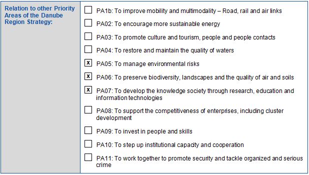
EUSDR EMBEDDING
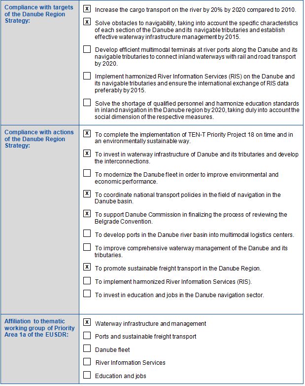
EUSDR COMPLIANCE
OTHER RELEVANT ISSUES
PROJECT REQUIREMENTS
Continuing international cooperation and mutual efforts on problem solution are required. Regulation and Waterways designs have to be harmonized and verified by both sides with the respect to the international conventions and agreements.
META DATA
Data provided by: Ana Barišić (Ministry of Maritime Affairs, Transport and Infrastructure, Croatia) – 20.11.2015
Last update by: Ana Barišić (Ministry of Maritime Affairs, Transport and Infrastructure, Croatia) – 27.01.2017
Download pdf


